Disclaimer: The travel advice available here is given in good faith, but with no guarantees. Road layouts do change over time and it can be difficult to relate travel descriptions with what is seen when driving and navigating, therefore the user of this information must not rely solely on the details here. The user is responsible for verifying the accuracy and suitability of this data for himself.
The Roussillon area:

Assuming travel from the UK, the choice is either a budget airline to one of five or six local airports or car plus ferry or Eurotunnel. There is a MotorRail option, but this can be expensive. If you are driving all the way, you can pick up these directions from the Le Boulou interchange lower down the page (driving from the U.K. may require an overnight stop - Clermont-Ferrand is well-placed).
Perpignan, Carcassonne and Girona are all reasonable journey-times (up to two hours), but if the fares were attractive enough, then the other airports are close to motorways and don't represent much more than 3 hours driving.
If you are flying, you'll need a car. We always used to use ‘Holiday Autos’ - but if you are flying to Gerona, you can try ‘Gold Car’, who may prove cheaper. If you are hiring in France, do make sure that there isn’t any mileage charge once a certain number of ‘free miles’ are completed!
National speed limits are 90 kph (56 mph) for single carriageways, 110 kph (68 mph) for dual carriageways and 130 kph (80 mph) in fine weather for motorways (110 kph in poor weather). Note that the limit on Spanish motorways is 120 kph. Also in towns and villages in France the limit will either be 50 kph or even 30 kph.
When driving in French villages and towns in our area, you should assume that ‘priority to the right’ is in force. If a road on the right joining the one you are on doesn’t have a dotted or solid white line across it, other drivers, coming from your right, will assume that they have priority! Similarly, if you are joining a road by turning right into it, other drivers will sometimes (but not always) stop to give you priority.
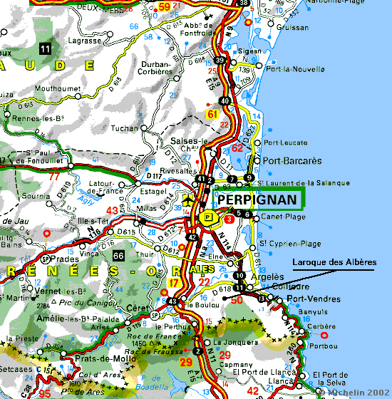
The journey from Perpignan Airport (the nearest destination) to Laroque is about 25 kilometres. The distance from Girona (the next nearest airport) is about 85 kilometres and from Barcelona airport it is about 150 kms.
The French Route Nationale system (the 'N' roads) has been regionalised in 2006 and the major 'N' roads (like the N9 in our area) have been changed to 'D' designations. For example the N9 has become the D900 and the N114 the D914. However plenty of the old signs still exist, so be prepared for both designations!
Directions from each of the three nearest airports to Le Boulou on the A9/E15 are given next.
The directions from Le Boulou to Laroque are given last.
Perpignan Airport to Le Boulou
The journey from the Perpignan Airport to Le Boulou divides into two sections:
Perpignan Airport to the A9/E15.
The route starts by leaving the rental car park at Perpignan airport (you will have been given a code to get through the security barrier):
The A9 to Le Boulou.

Once on the A9, you have a simple run of about 20 Kms down to the Le Boulou exit. Look out for the views of Canigou on the right, after some 10 Kms.
Girona Airport to Le Boulou

This airport has the simplest journey to reach the A7/E15 for France and Le Boulou. It is only a few kilometres - you leave the airport car park by the only road, and shortly you pass under the motorway and then meet a roundabout, where you take the exit for the A7/E15 north for Girona, La Jonquera and Francia (or FranÁa in Catalan). Simply stay on the motorway for about an hour and after passing the customs area the next exit is for Le Boulou.
Barcelona Airport to Le Boulou

Barcelona Airport is tucked away to the south-east of Barcelona and has a network of motorway and dual-carriageway roads linking up with the E15/A7 motorway going north to France. I can only suggest you study this and other maps, pay attention on the route to all the signs for Girona or Franca/Francia, and don't head into Barcelona. Leaving Barcelona airport you pickup the B22 for Girona. You will soon see signs for the E90/A2, still for Girona and after that signs for E90/AP2 again for Girona. After that you will see a sign for the E15/AP7 for Francia/Franca and that motorway will take you all the way to the border crossing. Allow 2 to 3 hours to complete the journey to Laroque.
Le Boulou to Laroque


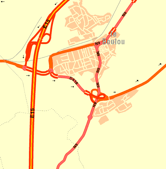
The Le Boulou motorway exit (Jn. 43) is signposted for Prats des Mollo, Le Perthus and maybe Ceret, but once you have cleared the ‘Péage’, you will see Argelès and Port-Vendres signposted on the first roundabout that you come to on the D115.
Laroque village plan

Contact us:
Email: Telephone: 0033 468 87 17 35
Please note that the above email link may not work if you are behind a Company firewall and will not work if you only have a web-based email facility, such as Googlemail or Hotmail.